Priory House Dunstable
Laser Scanning and Modelling
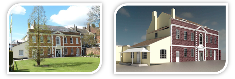
Stanburys Ltd were approached to undertake a series of metric surveys on the Priory House and Tea Rooms, Dunstable as part of an ongoing monitoring and refurbishment project. Notably this involved a topographical survey, building elevations, sections and floor plans, with the client keen to have a means of viewing the survey results in a 3 dimensional, easily understood form which it was decided should take the form of a computer generated model. So as to record and capture the structure in as short a time frame as possible, laser scanning was selected as the method of data capture.
What was the deliverable output?
Firstly a WebShare of the scan project was supplied to the client as a visual record of the environment within and immediately external to Priory House. This enables the client to fully interrogate the survey data, extracting measurements or coordinates and to mark-up and annotate, exporting screen shots as required.
Scan data was also supplied in registered e57 file format, which being the industry recognised standard for laser scan data should enable future import into most laser scan software solutions.
As a means of further visualising and viewing the building, an Autodesk Revit model (.rvt file format) was supplied along with a selection of static and stereoscopic renderings that were produced in both Revit and 3DS Max and rendered in the cloud.
This model could be further developed if required for future projects which might prove useful given the government’s stance on implementing BIM, which whilst statutory for larger buildings only will inevitably filter down to smaller structures in time.
To complete the deliverables building elevations, floor plans and sections were pulled from the model and supplied to the client.
Second World War & Holocaust Galleries
Laser Scanning and Modelling at IWM London
![]()
Upon recommendation Stanburys Ltd were approached to undertake a laser scanning and modelling exercise as part of a major BIM (Building Information Modelling) driven refurbishment of large parts of the museum space at IWM Lambeth Road.
Areas to be upgraded and improved included main exhibition halls, libraries, museum stores, training and education areas, as well as administrative and clerical spaces.
Owing to the above and a desire to record and capture the required areas in their entirety in as short a time frame as possible laser scanning was selected as the method of data capture.
In addition to laser scanning Stanburys were tasked with producing the initial computer generated 3D model to an agreed level of detail, which would then be developed as part of the BIM process.
What was the deliverable output?
Firstly a WebShare (standalone 360o viewing software) of the entire scan project was supplied to the client as a visual record of the survey areas within the museum. This enabled the client to fully interrogate the survey data, extracting measurements or coordinates and to mark-up and annotate, exporting screen shots as required.
Scan data was also supplied in registered e57 file format, which being the industry recognised standard for laser scan data should enable future import into most (if not all) laser scan software solutions.
An Autodesk Revit model (.rvt file format) was supplied to the client. The model was also delivered in IFC file format for development in other software solutions.